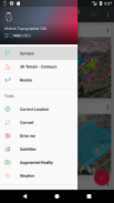
Mobile Topographer GIS


คำอธิบายของMobile Topographer GIS
ทางเลือกที่รักของมืออาชีพ
มือถือผ้าขี้ริ้ว ... ตรงกับ ...
GIS
ตอนนี้คุณสามารถดำเนินการสำรวจที่สมบูรณ์โดยไม่มีข้อ จำกัด ใด ๆ ที่เป็นความซับซ้อนหรือปริมาณของข้อมูล
ลองตอนนี้มือถือผ้าขี้ริ้ว GIS โดยใช้สามวันระยะเวลาทดลองใช้ฟรี เพียงดาวน์โหลดแอพพลิเคและปฏิบัติตามขั้นตอนการสมัครสมาชิกเขา ถึงแม้ว่าคุณจะถูกถามในการให้ข้อมูลการเรียกเก็บเงินคุณจะไม่ถูกเรียกเก็บเงินก่อนสิ้นสามวันของรอบระยะเวลาทดลองใช้ฟรี คุณสามารถยกเลิกการสมัครของคุณได้ตลอดเวลาในช่วงระยะเวลาการทดลองสามวันเสียค่าใช้จ่าย ค่าใช้จ่ายที่จะเกิดขึ้นถ้าในตอนท้ายของสามวันคุณยังคงมีการสมัครใช้งาน.
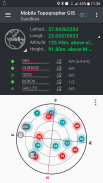
- เก็บอ่าน GNSS ใช้เพิ่มความแม่นยำ (GPS, GLONASS, กาลิเลโอ, Beidou กลุ่มดาว QZSS สนับสนุน)
- เชื่อมต่อรับสัญญาณ GNSS ภายนอกของคุณผ่านทางสถานที่จำลองและใช้มือถือ Topogrpaher GIS เป็นหน่วยประมวลผล
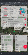
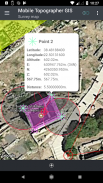
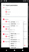
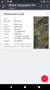
- แสดงข้อมูลลงใน CRS WGS84 ท่านคาดการณ์ในท้องถิ่น
- แปลงจาก WGS84 การคาดการณ์ในท้องถิ่น CRS และในทางกลับกัน
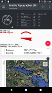
- ประมาณการเวลาจริงบนแผนที่
- *** NEW *** ภาพที่กำหนดเองหรือ WMS เซิร์ฟเวอร์เป็นพื้นหลังของแผนที่
- ค้นหาจุดที่ทำเครื่องหมายไว้ในโลกแห่งความจริงโดยใช้ไดรฟ์ "ฉัน"
- ความสูงคำนวณ Orthometric ในการบินโดยใช้รูปแบบการประชุมวิสามัญผู้ถือหรือกริดระดับความสูงที่มีให้บริการในท้องถิ่น
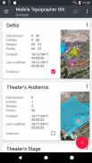
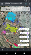
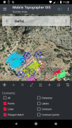
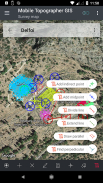
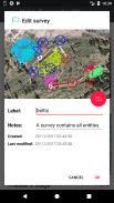
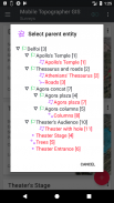
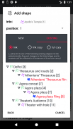
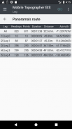
- จัดระเบียบงานของคุณเป็นสิ่งที่น่า - รูปร่าง - หน่วยงานและแบบสำรวจ ขณะนี้คุณสามารถสร้างจุดแต่ละกลุ่มหลายจุดเส้น multipart และรูปหลายเหลี่ยมหลายส่วนที่มีรู
- สร้างภาพวาดที่เต็มไปด้วยรายละเอียดมากเท่าที่คุณต้องการ
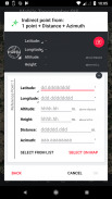
- *** NEW *** เครื่องมือ Geodetic เพิ่มจุดโดยอ้อมผ่านทางในตัวเลือกต่อไปนี้: 1 จุดระยะทาง + + Azimuth, 2 จุด + ระยะทาง + เลือก 2 จุด + azimuths 3 จุด + ระยะทาง, จุดกึ่งกลางของเส้นเส้นแบ่งขยายบรรทัดบรรทัดขนานตั้งฉากกับสาย .
- Nest งานของคุณในระดับใดทำรังเพื่อสร้างซุปเปอร์สำรวจ
- แบ่งปันข้อมูลระหว่างงานมีการเชื่อมโยงการใช้งาน
- งานแลกเปลี่ยนระหว่างโทรศัพท์มือถือและคอมพิวเตอร์เดสก์ทอปของคุณกับการนำเข้า - ส่งออกฟังก์ชั่นการใช้ทุกรูปแบบทั่วไป .txt, .csv, .kml, .gpx, .DXF และรูปร่างไฟล์ (.shp - shx ไว้ด้วย - .dbf)
- การทำงานร่วมกับคู่ค้าของคุณโดยการแลกเปลี่ยนและแบ่งปันจากจุดหนึ่งไปให้งาน
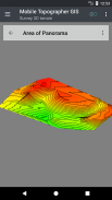
- สร้างภูมิประเทศ 3 มิติของพื้นที่โดยเพียงแค่เดินผ่านมัน
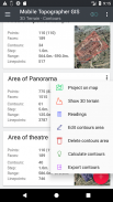
- การคำนวณรูปทรงและเพิ่มพวกเขาเข้าไปสำรวจของคุณด้วยความเร็วฟ้าผ่า
- ดูรูปแบบ 3 มิติที่แท้จริงโดยตรงลงในอุปกรณ์ของคุณ
- เก็บเส้นทางที่มีข้อมูลของ
- ดาวเทียม GNSS แสดงสัญญาณที่มีข้อมูลทั้งในมุมมองเข็มทิศหรือ AR
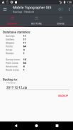
- สำรองและกู้คืนข้อมูลของคุณโดยใช้ไฟล์ SQL .db
ยินดีต้อนรับสู่ยุคของการสำรวจโทรศัพท์มือถือที่ ... !
ค้นหาข้อมูลเพิ่มเติมเกี่ยวกับมือถือผ้าขี้ริ้วระบบสารสนเทศภูมิศาสตร์ใน:
http://applicality.com/projects/mobile-topographer-gis/
ดาวน์โหลดคู่มือผู้ใช้จาก:
http://applicality.com/app_documentation/web/MobileTopographerGIS_Manual.pdf


Mobile Topographer GIS - ข้อมูล APK
เวอร์ชั่น APK: 6.0.15แพ็คเกจ: com.applicality.mobiletopographergisเวอร์ชั่นล่าสุดของMobile Topographer GIS
เวอร์ชั่นอื่น


 4.15
4.15


แอปในประเภทเดียวกัน